Bark’s Advocacy Leads to Changes to 27 Road Fuel Break CE!
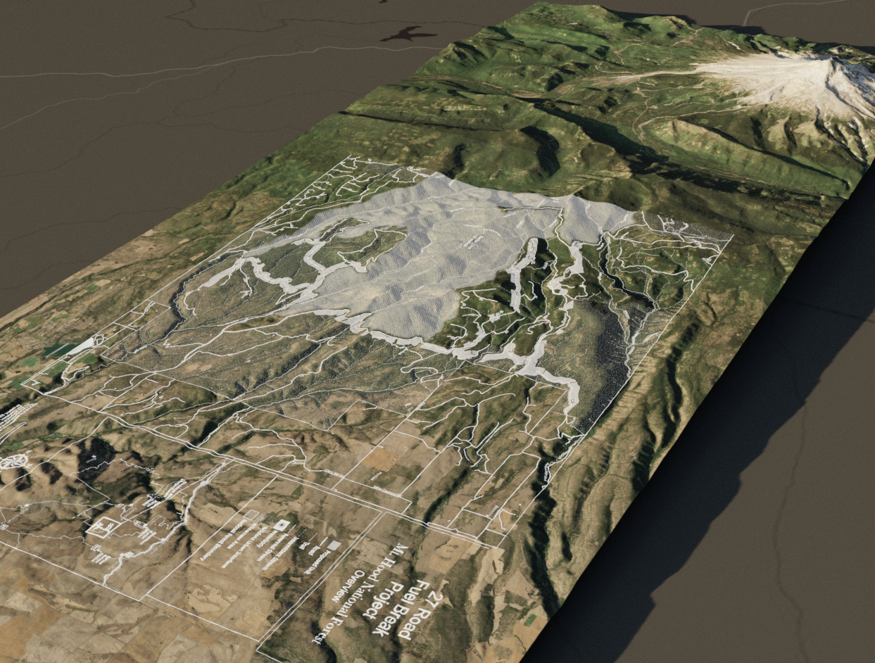
The Barlow District Ranger on Mt Hood NF announced their decision to move forward with the creation of a fuel beak along portions of the 27 road system east of Badger Creek Wilderness–but with some important changes proposed by Bark!
Here’s a summary of what changed:
- 234 acres of forest designated as Late-Successional Reserve (LSR) have been dropped from the project. Forests with an LSR designation are intended to be managed to protect and enhance old-growth forest characteristics.
- Project design should now prioritize the retention of the largest and oldest (and most fire resistant!) trees in each individual stand and across the project area. (It’s important to point out here that the fuel break law, as written, has no explicit protections for large and old-growth trees.)
- Bark groundtruthers found that a wetland extended beyond the mapped boundaries. Guidelines were established that will protect this sensitive area from disturbance.
These changes to the project are a direct result of Bark staff and volunteers surveying the project area, and I personally shared these concerns with the Forest Service on collaborative field tours, meetings with the Wasco County Forest Collaborative, and through Bark’s (and volunteers’) NEPA comments on the project.
In fact, in June of last year, during a field tour of the project with the Wasco County Forest Collaborative, I managed to snag a seat in Rick’s truck. Rick is the Fire and Fuels Manager for the east zone of Mt Hood NF, and so his truck has the cool green stripes with “FIRE” written along the side. As we bounced around bumpy forest roads between tour stops, I was able to hear first-hand his perspective on the project and his ideas for dry forest restoration.
From the beginning of this project’s proposal back in May of last year, Bark has stayed consistent in communicating concerns about the fuel break with Forest Service staff. We argued three main points:
- Wide variations in elevation, forest type, and past logging created complexities that could not be adequately addressed by a project that didn’t legally require an in-depth environmental assessment.
- Creating a fuel break through the heart of an LSR did not mesh with the purpose of the LSR designation.
- Logging large and old trees does not follow the science of dry forest restoration.
Back in the truck, Rick and I went back and forth on where we agreed and disagreed, and I picked his brain on how we get to a place where fire can once again play its natural role in Northwest forests. Rick wants to see that happen, too, and has been working to grow the prescribed fire program on the east side. We both want to see the increased use of beneficial fire in dry forests.
Later on at the final tour stop, Andrew, the group facilitator, asked us how we felt about the project thus far. I expressed my concerns (listed above) and shared some of what Bark volunteers and I had found during groundtruthing surveys. While not everyone in the group agreed (total consensus on forest projects is rare and difficult to achieve), I do feel that they understood my perspective and felt that my concerns were reasonable.
Folks, at a time when much of the news we consume leaves many of us feeling discouraged and disempowered, this success–however modest–is a reminder that direct action and public engagement work.
And while this may be the formal end of the NEPA process for this project, Bark will continue to monitor on-the-ground conditions in the forest as the project is being implemented. Our findings will help to influence future projects on the Forest.
Thank you to each and every one of you who volunteered your time to groundtruth this project or write a comment for it! Your efforts have not gone unnoticed.
Learn more!
- Where did the Fuel Break CE come from? In 700 words tucked into the 1,000-page Bipartisan Infrastructure Law of 2022, Congress gave federal agencies authority to use this new project type that is “categorically excluded” from a more robust NEPA process. Read more about the use of “Categorical Exclusions” in Mt. Hood.
- Read an overview of the 27 Road Fuel Break CE and associated documents and maps.
- Read about the ecology and politics of fire, and how they shaped the 27 Road Fuel Break.